
ANALISIS PENGINDERAAN JAUH DAN PEMODELAN 3D FAULT FRACTURE DENSITY (FFD) DALAM PENENTUAN ZONA PERMEABILITAS PERMUKAAN DI WILAYAH PANAS BUMI GUNUNG TAMPOMAS, JAWA BARAT
REMOTE SENSING ANALYSIS AND 3D FAULT FRACTURE DENSITY (FFD) MODELING INTO DETERMINATION OF SURFACE PERMEABILITY ZONES IN MOUNT TAMPOMAS GEOTHERMAL AREA, WEST JAVA
Abstract
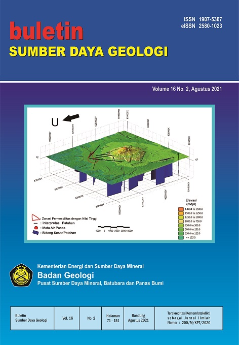
The area of Mount Tampomas which is located in Buahdua District, Conggeang District, and Tanjungkerta District, Sumedang Regency, West Java was chosen as the research area because it is predicted to have geothermal potential with the presence of geothermal manifestations such as hot springs. The presence of manifestations relates to permeable zones controlled by geological structures. The lineament of the ridge and valley was observed and analyzed using ASTER GDEM remote sensing imagery and Indonesia Earth Form map (RBI), scale 1:25.000. The purpose of the study is to find out the relationship between permeability and the presence of geothermal manifestations in the research area. Research method by conducting remote sensing and fault fracture Density (FFD) analysis using 3D micromine software modeling. Results of remote sensing analysis with irradiation angle of 0°, 45°, 90°, 135° and altitude 45° shows the main pattern of the ridge - valley lineament interpreted as a fault in the research area have a relatively northwest-southeast and northeast-southwest direction. Indications of geological structures in the field are shown by the morphology of valley-ridges, in some places has a steep slope that form the fault escarpment and triangular facet. The FFD analysis results in the research area have varying permeability classes shown by low FFD values (0.00–3.00 km-1), medium (3.00-6.00 km-1) and high (6.00–9.33 km-1). The geothermal manifestations appear in the permeability zone that have medium to high FFD values marked by orange and red colors. From 3D micromine software modeling of the permeability zone and plotting of hot springs on the surface, it is clear that the appearance of hot springs to the surface is facilitated by faults that develop in the research area.
Downloads
References
Anonim,. 2020. Current Geothermal Landscape and Government Objective for Future Development [Dokumen PDF]. Direktorat Jenderal Energi Baru, Terbarukan, dan Konservasi Energi Diperoleh dari Catatan Kuliah online.
----------------------. Peta Per wilayah Provinsi Jawa Barat. Indonesia Geospatial Portal. Portal Geospasial Indonesia. Diakses pada 15 Oktober 2020.
Dirk, H. J. M. 2008. ‘Petrologi - geokimia Batuan Gunung Api Tampomas dan sekitarnya’. Jurnal Geologi Indonesia. Vol. 3, no. 1, hal. 23-35.
Febyani, S., Pradhana K.M.F., Rivaldy, M., Syafri, I., Nur, A.A, Embara, P. & Nugroho, S.D. 2020. ‘Analisis Kerentanan Gempa pada Jalur Sesar Baribis Menggunakan Metode Microearthquake (Meq)’. Bulletin of Scientific Contribution Geology. Vol. 18, no. 1, hal. 1-12.
Gentana, D., Sukiyah, E., Sulaksana, N & Yuningsih, E.N 2017, ‘Determination Tanggamus Geothermal Prospect Area, Lampung Province, South Sumatra Based on Remote Sensing and 3D Micromine Software’, FIG Working Week, Helsinki, Finland, May 29–June 2, 2017.
Gentana, D., 2018. Indeks Geomorfik Sebagai Dasar Karakterisasi Neotektonik Untuk Penentuan Prospek Panas bumi di Gunung Rendingan dan Sekitarnya, Lampung. Disertasi. Fakultas Teknik Geologi Universitas Padjadjaran, Bandung.
Haryanto, I., & Hilmi, F. 2008. ‘Pola Struktur Regional Jawa Barat’. Bulletin of Scientific Contribution Geology. vol. 5, no. 1, hal. 57-66.
Haryanto, I. 2014. Evolusi Tektonik Pulau Jawa Bagian Barat Selama Kurun Waktu Kenozoikum. Disertasi. Fakultas Teknik Geologi Universitas Padjadjaran, Bandung.
Hermawan, D., & Rezky, Y. 2011. ‘Delineasi Daerah Prospek Panas Bumi Berdasarkan Analisis Kelurusan Citra Landsat di Candi Umbul - Telomoyo, Provinsi Jawa Tengah’. Buletin Sumber Daya Geologi. Vol. 6, no. 1, hal. 1-10.
Kasbani. 2009. ‘Tipe Sistem Panas Bumi di Indonesia dan Estimasi Potensi Energinya’. Buletin Sumber Daya Geologi. vol. 4, no. 3, hal. 19-26.
Massinai, M.A. 2015. Geomorfologi Tektonik. Pustaka Ilmu. Yogyakarta.
Prasetio, R., Laksminingpuri, N. & Satrio. 2018.‘Karakteristik Kimia dan Isotop Fluida Panas Bumi Daerah Gunung Tampomas, Jawa Barat’. Riset Geologi dan Pertambangan. Vol. 28, no.1, hal. 1-11.
Prasetio, R., Laksminingpuri, N. & Pujiindiyati, E.R. 2020. ‘Konsentrasi Radon-222 dalam Gas Tanah untuk Deteksi Distribusi Permeabilitas di Daerah Panas Bumi Tampomas, Jawa Barat’. Eksplorium. Vol. 41, no. 1, hal. 53-60.
Sasilani, R., Haryanto, A.D., Hutabarat, J., Hermawan, D & Widodo, S. 2019. ‘Zone of Geothermal Prospects Based on Fault Fracture Density (Ffd) Method in Sumani Region, West Sumatera’. Journal Of Geological Sciences and Applied Geology. Vol. 3, no. 2, hal. 22-35.
Siagian, R., Maryudi, M. & Purba, V. 2018. ‘Integrated Research for Geothermal Prospect Zone of Lawu Mountain Based on Geothermal Manifestation, Rock Alteration, Geochemical Analysis of Fluid, Fault Fracture Density and Magnetotelluric Data’. Proceedings of the 6th Asian Academic Society International Conference (AASIC). Hal. 595-604.
Silitonga, P.H. 1973. Peta Geologi Lembar Bandung, Jawa. Skala 1:100.000. Bandung: Pusat Penelitian dan Pengembangan Geologi.
Suryantini, & Wibowo, H.H,. 2010. ‘Application of Fault and Fracture Density (FFD) Method for Geothermal Exploration in Non-Volcanic Geothermal System; a Case Study in Sulawesi-Indonesia’. Jurnal Geoaplika. Vol. 5, no. 1, hal. 027 – 037.
Thanoun, R.G. 2013. ‘Automatic Extraction and Geospatial Analysis of Lineaments and their Tectonic Significance in some areas of Northern Iraq using Remote Sensing Techniques and GIS’. International Journal of Enhanced Research In Science Technology & Engineering. Vol. 2, no. 2, hal. 1-11.
Twidale, C.R., 2004. ‘River Patterns and Their Meaning’. Earth-Science Reviews. Vol. 67, no. 3-4, hal. 159-218.
Copyright (c) 2021 Buletin Sumber Daya Geologi

This work is licensed under a Creative Commons Attribution-NonCommercial-ShareAlike 4.0 International License.
Authors whose manuscripts are published agree to the following terms:
The publication rights of all journal manuscript materials published on the Buletin Sumber Daya Geologi website are held by the editorial board with the knowledge of the author (moral rights remain with the manuscript’s author).
The formal legal provisions for access to digital articles in this electronic journal are subject to the terms of the Creative Commons Attribution-ShareAlike (CC BY-SA) license. This means that Buletin Sumber Daya Geologi has the right to store, convert media/formats, manage in the form of a database, maintain, and publish the article without requesting permission from the author, as long as the author’s name is cited as the copyright holder.
Manuscripts published in both print and electronic formats are open access for educational, research, investigative, and library purposes. Beyond these purposes, the editorial board is not responsible for any violations of copyright law.